
WinLoG Geophysical Water Supply Example

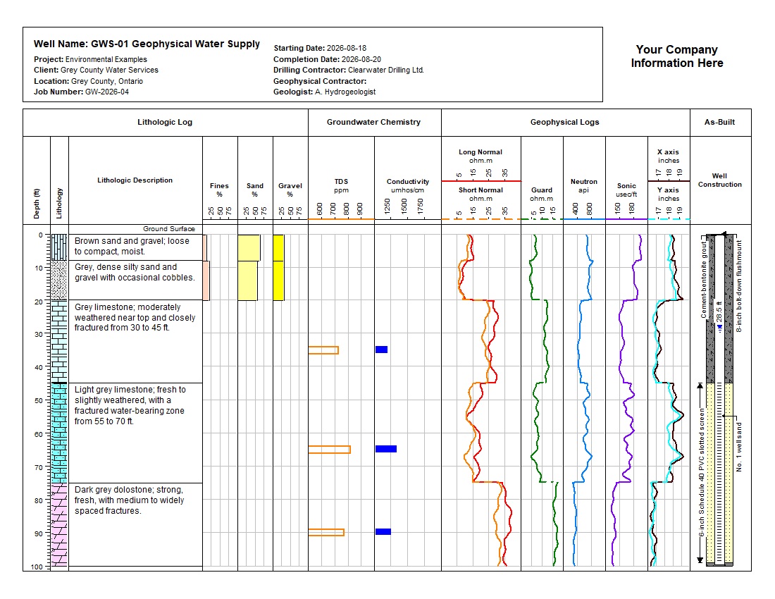
WinLoG geophysical water-supply log with lithology, chemistry, resistivity, neutron, sonic, caliper, and well construction View Page 1
Geophysical Water Supply Log
1-page log Validation Passed
GEOPHYSICAL WATER SUPPLY EXAMPLE

WinLoG Geophysical Water Supply Example

Lithology, groundwater chemistry, seven geophysical curves, dual-axis caliper, and as-built construction.

This example shows how WinLoG integrates a water-supply well record with downhole geophysical measurements. GWS-01 Geophysical Water Supply combines lithology, particle-size percentages, groundwater chemistry, long- and short-normal resistivity, guard, neutron, sonic, dual-axis caliper, and as-built construction on one depth scale.

The 100 ft well penetrates sand and gravel, silty sand and gravel, limestone, and dolostone. Seven geophysical curves are sampled every 0.25 ft, while TDS and conductivity results, particle-size data, casing, grout, screen, filter pack, and water level provide supporting context. Automated validation reports Passed, 100% completeness, 85% confidence, and no warnings or errors.

Environmental Groundwater Geophysics Well Construction Resistivity & Caliper Neutron & Sonic Validation Passed XML Template

Download Complete Example Back to Example Library

Capabilities Demonstrated

What This Geophysical Water Supply Example Shows

Lithology & Gradation

  • Lithology and descriptions
  • Lithologic symbols
  • Fines, sand, and gravel percentages
  • Two unconsolidated intervals
  • Three bedrock intervals
  • Five lithologic intervals

Groundwater Chemistry

  • Total dissolved solids
  • Electrical conductivity
  • Three depth-linked test intervals
  • TDS values from 720 to 810 ppm
  • Conductivity from 1,180 to 1,320 umhos/cm
  • Chemistry beside formation data

Geophysical Curves

  • Long- and short-normal resistivity
  • Guard resistivity
  • Neutron response
  • Sonic travel time
  • Caliper X and Y axes
  • 401 values per curve at 0.25 ft

As-Built & Validation

  • 6-inch PVC casing and screen
  • Cement-bentonite grout and filter sand
  • Passed validation status
  • 100% completeness and Good quality
  • 85% confidence score
  • No warnings or errors

Formation, Chemistry, Geophysics, and Construction Together

This record demonstrates how formation descriptions and particle-size data can be reviewed beside groundwater chemistry, seven continuous geophysical curves, and a detailed completion diagram. The shared depth scale makes it easy to relate curve response and borehole enlargement to lithology, water-bearing fractures, casing, grout, screen, and filter-pack placement.

The supplied validation report records Passed status, 100% completeness, Good quality, an 85% confidence score, zero warnings, and zero errors.

Example Data

Key Datasets Demonstrated

Lithology and Groundwater Data

  • Sand and gravel over limestone and dolostone
  • Five depth-continuous lithology intervals
  • Water-bearing fracture zone from 55 to 70 ft
  • Fines, sand, and gravel percentages
  • Three TDS and conductivity intervals

Construction and Geophysics

  • Long Normal, Short Normal, and Guard resistivity
  • Neutron and sonic response
  • Caliper X- and Y-axis measurements
  • As-built construction to the 100 ft well depth
  • Importable WinLoG XML datasets

Download the Complete Example

Download the example files individually. The XML template and log can be imported into WinLoG Version 6 and customized for water-supply and groundwater workflows.

Included in the Example

  • Professional one-page geophysical water-supply log
  • Geophysical water-supply validation report
  • Reusable XML template
  • Geophysical Water Supply XML borehole data
  • Lithology, chemistry, seven geophysical curves, and construction datasets
Applications

Who This Example Is For

Hydrogeologists

Demonstrates a practical workflow for correlating aquifers and water-bearing fractures with chemistry, borehole geophysics, and final construction.

Geophysicists

Shows long- and short-normal resistivity, guard, neutron, sonic, and dual-axis caliper curves sampled consistently at 0.25 ft.

QA/QC Reviewers

Provides an integrated record for reviewing formation data, construction depths, geophysical response, completeness, and consistency.

Customize This Geophysical Water Supply Example

WinLoG templates can be customized to match company standards, project requirements, and agency formats. Construction components, lithology, groundwater chemistry, geophysical curves, curve colors and scales, and validation rules can be tailored to project requirements.

Contact GAEA Technologies