Geoscientific Analysis Solution

Simplifying Geoscientific Analysis for Everyone

Are you frustrated with complicated software tools?



svg icon 


Difficulty navigating complex interfaces.

svg icon 


Inability to understand your software effectively.

svg icon 


Wasted time on ineffective analyses.

svg icon 


Limited collaboration with team members.

svg icon 


Stress over missed project deadlines.

svg icon 


Overwhelmed by unnecessary features and options.

image
choose images
svg icon 


Streamline your analysis process effortlessly.

svg icon 


Feel confident with intuitive geoscience tools.

svg icon


Achieve results faster without the hassle.

svg icon


Unlock potential with user-friendly solutions.

We Understand Your Challenges

With 3,000+ clients worldwide, we have the solution you need.

svg icon

3,000+ Companies Trust Us

Join thousands who rely on our software for their projects.


svg icon

120+ Countries Use Our Solutions

Working globally to simplify geotechnical and geoscientific data handling.


svg icon

Created by Professionals Like You

Engineered and designed for performance—trusted by professionals like you.

Transform Chaos into Clarity with GaeaSynergy

Transform your geoscientific analysis with GaeaSynergy software, designed for engineers and geoscientists frustrated by complicated tools. Download the demo, purchase, and streamline your workflows. Say goodbye to confusion and hello to clarity as you easily model subsurface data. If you're tired of struggling, try our software now and experience success with straightforward solutions.

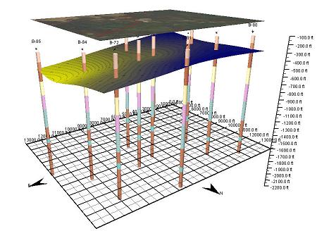
GaeaSynergy is an application suite for geoscientific analysis, mapping, data display and data management. It uses the synergy within the geoscientific data to effectively and efficiently fulfill the needs of several industries. The program can be used to evaluate contaminants, soil and rock properties, mineral deposits, and oil and gas deposits. It is ideal for the environmental, geotechnical, mining, oil sands, and petroleum industries.

GaeaSynergy is comprised of a base application and several optional modules. The base application is free and is used as a platform that all of the other modules build upon. The base application consists of the following components:

  • Data Management
  • License Management
  • User Management
  • Geographic Information System
  • Mapping and Gridding
  • 3D Display
  • Import/Export


Optional Modules

Using the optional modules, the program can be used to generate geotechnical test results and reports, lab analyses reports, boring and well logs, cross-sections, and fence diagrams. The following optional modules are available:

  • EDMS: Environmental Data Management System
  • GDMS: Geotechnical Data Management System
  • WinLoG: Well and Boring Log Module
  • WinFence: Cross-section Module

3 Simple Steps to Simplify Your Geoscientific Analysis

Quickly experience seamless analysis that reduces frustration and enhances productivity.

svg icon

Download the Demo

Start your journey with a free trial today.



svg icon

Purchase and Register

Make your purchase to unlock full features.


svg icon

Enjoy easy analysis

Get your work done faster with less stress.

Stop struggling with complicated software; simplify your geoscientific analysis today.

As an engineer or geoscientist, you know the frustration of dealing with complicated software that complicates your work rather than simplifying it. We believe you shouldn't have to struggle with ineffective tools that overwhelm you. Our geoscientific analysis software is designed specifically for professionals like you, created by engineers and geoscientists who understand your challenges. Download our demo to see how easy it is to transition to a solution that enables you to get work done faster, with less stress. Experience the confidence of mastering your analysis capabilities and unlock opportunities for growth while avoiding the pitfalls of complex tools.


Thank you for your interest in our software solutions. Please use the link below to download our free geotechnical utilities app, that can be used for soil classification and other common soil and concrete tests.